Mount Tamalpais hike for brilliant views of San Francisco Bay Area

While in San Francisco Bay Area, if you want to witness some of the brilliant views of the bay, San Francisco city and enjoy some of the beautiful hikes, Mount Tamaplais is a brilliant place to plan. This post would take you through our hiking experience to Mount Tamalpais and how we optimized our day in such a way that we could visit the famous Muir Woods National Park as well.

While in San Francisco Bay Area, if you want to witness some of the brilliant views of the bay, San Francisco city and enjoy some of the beautiful hikes, Mount Tamaplais is a brilliant place to plan. This post would take you through our hiking experience to Mount Tamalpais and how we optimized our day in such a way that we could visit the famous Muir Woods National Park as well. 

There are plenty of hiking trails on Mount Tamapais and many of them expose you to brilliant views of San Francisco City, Bay Bridge, Golden Gate Bridge and various other neighborhoods. Diversity of California state in USA offers lot of such amazing aerial views.

There are plenty of hiking trails on Mount Tamapais and many of them expose you to brilliant views of San Francisco City, Bay Bridge, Golden Gate Bridge and various other neighborhoods. Diversity of California state in USA offers lot of such amazing aerial views. 

We started our drive from Redwood City at 9am and it took significant time to reach Mount Tamalpais. It's in Marin county of California state in USA. We reached the first parking slot around Mount Tamalpais, we got our parking ticket, which costs $8 and applicable for all the parking slots on the hill till the extreme point on the top where road ends.

We started our drive from Redwood City at 9am and it took significant time to reach Mount Tamalpais. It's in Marin county of California state in USA. We reached the first parking slot around Mount Tamalpais, we got our parking ticket, which costs $8 and applicable for all the parking slots on the hill till the extreme point on the top where road ends.
Above photograph shows photograph of colorful plants on the hill. Some of the trails on mount Tamalpais, which are lower elevation valley trails, lead into natural, dense groves of mature Douglas-fir and redwood trees, clear, open grassland, and shrub-lands.

Above photograph shows photograph of colorful plants on the hill. Some of the trails on mount Tamalpais, which are lower elevation valley trails, lead into natural, dense groves of mature Douglas-fir and redwood trees, clear, open grassland, and shrub-lands. 

Initial plan was to hike around the very first stop on this mountain, but when we interacted with the lady on parking ticket counter, she suggested us to go further till the last parking space. The reason what that hike around the peak is relatively very small and offers great views. It was hardly 20 minutes hike and it exposed us to some mind-blowing views.  Some of these trails on Mount Tamalpais, including the mountaintop or ridge top trails, have views of the San Francisco Bay and Pacific Ocean.

Initial plan was to hike around the very first stop on this mountain, but when we interacted with the lady on parking ticket counter, she suggested us to go further till the last parking space. The reason what that hike around the peak is relatively very small and offers great views. It was hardly 20 minutes hike and it exposed us to some mind-blowing views.  Some of these trails on Mount Tamalpais, including the mountaintop or ridge top trails, have views of the San Francisco Bay and Pacific Ocean.

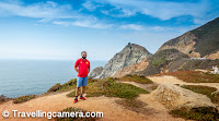
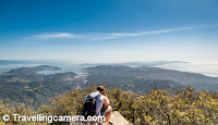
As you reach the top of the mountain, you can walk around the tip of the mountain. One half of the walk exposes you to these views of the bay. Notice the tip of Golden Gate Bridge in the middle of mountains.

As you reach the top of the mountain, you can walk around the tip of the mountain. One half of the walk exposes you to these views of the bay. Notice the tip of Golden Gate Bridge in the middle of mountains. 

Above photograph shows Bon Temple lake and Lake Lagunitas. In the middle of green forest, these shiny blue lakes look amazing. These are opposite to the bay area. So while going up to the Mount Tamalpais, you see these lakes and as you hit the top, you see unimaginable views of bay, San Francisco city, Bay bridge, Golden Gate bridge, Aukland region, Pacifica beach and all.

Above photograph shows Bon Temple lake and Lake Lagunitas. In the middle of green forest, these shiny blue lakes look amazing. These are opposite to the bay area. So while going up to the Mount Tamalpais, you see these lakes and as you hit the top, you see unimaginable views of bay, San Francisco city, Bay bridge, Golden Gate bridge, Aukland region, Pacifica beach and all. 

More than hiking we drove more around these beautiful roads of Mount Tamalpais and stopped at various places to capture these beautiful views of the ocean.

More than hiking we drove more around these beautiful roads of Mount Tamalpais and stopped at various places to capture these beautiful views of the ocean. 

Since the Mount Tamalpais has many trails and trailheads that criss-cross the area. Many of these trails are used by hikers and bikers seeking refuge from the urban landscape of the San Francisco Bay Area.

Since the Mount Tamalpais has many trails and trailheads that criss-cross the area. Many of these trails are used by hikers and bikers seeking refuge from the urban landscape of the San Francisco Bay Area.  

Above photograph offers panoramic view of San Francisco City, Bay bridge and lot of other places on left of the city area.

Above photograph offers panoramic view of San Francisco City, Bay bridge and lot of other places on left of the city area. 

Just close to the main hike Mount Tamalpais, there is a museum about Mt Tamalpais & Muir Woods Railway. This railway line was a scenic tourist railway operating between Mill Valley and the east peak of Mount Tamalpais in Marin County, California, covering a distance of 8+ miles. The railroad was incorporated in January 1896, and closed in the summer of 1930.     "Crookedest Railroad in the World" the line was renowned for its steep and serpentine route, winding through picturesque terrain to a mountaintop tavern providing first class hospitality and striking views of the San Francisco Bay Area. Despite its popularity, the railway met its demise following a fire in 1929, and dwindling ridership when the automobile could finally drive to the mountain.

Just close to the main hike Mount Tamalpais, there is a museum about Mt Tamalpais & Muir Woods Railway. This railway line was a scenic tourist railway operating between Mill Valley and the east peak of Mount Tamalpais in Marin County, California, covering a distance of 8+ miles. The railroad was incorporated in January 1896, and closed in the summer of 1930. 

"Crookedest Railroad in the World" the line was renowned for its steep and serpentine route, winding through picturesque terrain to a mountaintop tavern providing first class hospitality and striking views of the San Francisco Bay Area. Despite its popularity, the railway met its demise following a fire in 1929, and dwindling ridership when the automobile could finally drive to the mountain.

All roads leading to the many trailheads around Mount Tamalpais are usually open, but during fire season some of these roads may be closed due to high fire risk.

All roads leading to the many trailheads around Mount Tamalpais are usually open, but during fire season some of these roads may be closed due to high fire risk.

While returning back from Mount Tamapais, we were heading towards Muir woods and Cushing Memorial Amphitheater comes on the way. This amphitheater has seating for 4000 people it seems, although I feel that it's a little exaggeration.

While returning back from Mount Tamapais, we were heading towards Muir woods and Cushing Memorial Amphitheater comes on the way. This amphitheater has seating for 4000 people it seems, although I feel that it's a little exaggeration. 

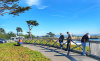
This photograph shows Cushing Memorial Amphitheater, with beautiful views of the bay and surrounded by high trees. I am sure it would be a delightful moment to watch shows in middle of this natural beauty.

This photograph shows Cushing Memorial Amphitheater, with beautiful views of the bay and surrounded by high trees. I am sure it would be a delightful moment to watch shows in middle of this natural beauty. 

During the weekends, many roads, paved and unpaved, which cross the Mount Tamalpais region are used by mountain bikers. Mount Tamalpais played a role in the birth of mountain biking many years ago. There has been considerable controversy over trail access for mountain bikes, both in terms of environmental impact and the safety of other trail users. As a result, bicycles have been banned from the majority of narrow, single-track trails, though bicycles are still allowed on fire roads. The fire roads on Mt. Tam are mixed-use and they are commonly used as running, hiking, biking and horseback riding routes.    If you are planning to visit Muir Woods, I would highly recommend driving around Mount Tamalpais and enjoy these panoramic views of the San Francisco Bay Area.

During the weekends, many roads, paved and unpaved, which cross the Mount Tamalpais region are used by mountain bikers. Mount Tamalpais played a role in the birth of mountain biking many years ago. There has been considerable controversy over trail access for mountain bikes, both in terms of environmental impact and the safety of other trail users. As a result, bicycles have been banned from the majority of narrow, single-track trails, though bicycles are still allowed on fire roads. The fire roads on Mt. Tam are mixed-use and they are commonly used as running, hiking, biking and horseback riding routes.


If you are planning to visit Muir Woods, I would highly recommend driving around Mount Tamalpais and enjoy these panoramic views of the San Francisco Bay Area. 

Related Blogposts -

A day well spent around hike to Mori Point, drive to Halfmoon Bay, Sunset party at States beach and late nigh celebrations at Foster City in CaliforniaA day well spent around hike to Mori Point, drive to Halfmoon Bay, Sunset party at State beach and late nigh celebrations at Foster City in California


Trending Post Today !

How to reach Kasol/Malana and top things to do around this stunning hill-station of Himalayan State of India

Main places to see & Top things to do around Dalhousie : Stunning Hill Station in Himalayan State of India